
Anatomy of a Junction: Two
North Western Storm Relief Sewer: Notting Hill
After years of dispute and deliberation Joseph Bazalgette (Chief Engineer of the Metropolitan Board of Works) was given a little short of carte blanche to reform London’s piecemeal drainage system, the clincher being the much documented ‘Great Stink‘ of 1858. Bazalgtte’s intercepting sewers constituted the lion’s share of the new main drainage works, with further improvements following their completion. On the north side of the Thames three west – east running sewers would receive content from London’s ancient valley lines, carrying the ill-scented flow out of the City to be discharged to the sea on the river’s ebb tide. The middle sewer of the three original interceptors runs for nine and a half miles, its dimensions for the first mile of this are a modest 4′ 6″ x 3′ and it’s along this stretch that the tale of our junction begins.
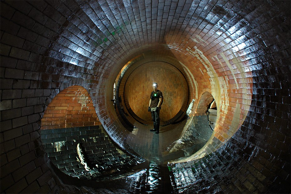
Pic. 1 – Ok. Somebody had better start explaining and fast!
Constructed c.1861 the first three quarters of a mile of the Middle Level Sewer No.1(MLS1) were run across farmland, though this was land being hastily encroached upon as middle-class suburbia steadily claimed ground. At the three quarter mile marker, where the tunnel first hit the streets, is where our junction begins. Beneath affluent avenues, lined with stucco fronted town houses, three distinct phases of work have formed a subterranean crossroads of intersecting arcs and impossible angles.
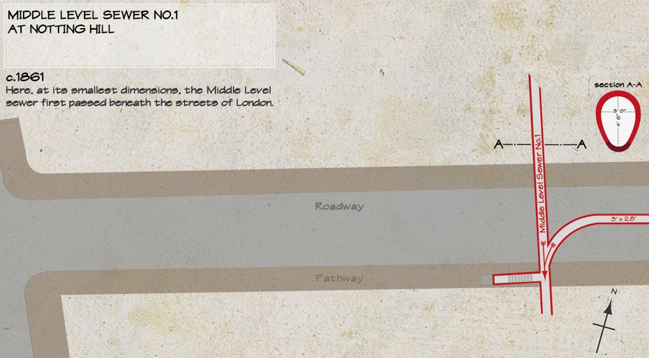
Fig. 1 – Phase one: Middle level sewer no.1 at Noting Hill, measuring 4′ 6″ x 3′ for the first mile of its course
Over the next forty years or so the city continued to grow and the area through which the first section of the MLS1 passed had become heavily urbanised, somewhat beyond forecasts. The increase in local sewer connections and paved surfaces had resulted in unacceptable instances of flooding during sustained or heavy rainfall. In 1904 the London County Council’s solution, under Chief Engineer Maurice Fitzmaurice, was the construction of a one and a quarter mile storm relief sewer, the North Kensington Relief(NKR). The new relief sewer would be the same dimensions for its entire length, a 5′ circular pipe, with a blue brick invert. At its upstream end overflow from the MLS1 would enter the relief via a small weir and tumbling bay. The overflow was conveyed south east to join the significantly larger Counters Creek Sewer at Holland Park Av.
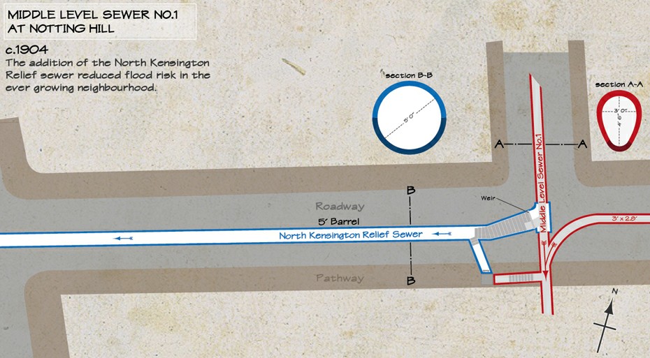
Fig. 2 – Phase Two: The addition of Maurice Fitzmaurice’s North Kensington Relief Sewer.

Pic. 2 – The overflow point, from Middle Level to North Kensington Relief.

Pic. 3 – Looking roughly north up the NWSRS, with the NKR on the right.
Pic.2 above looks up the York stone steps of the tumbling bay, at the top of which the MLS1 is contained by a low dam board weir. The final phase of works in 1924 propelled what was an interesting drain junction to another level, it also propelled a whole host of filth beneath the streets of Notting Hill and Kensington. Three quarters of a mile north east of our junction, in Maida Vale, residents were more than a little perturbed by the frequent re-surfacing of an old Thames tributary, one of London’s infamous buried rivers. The river Westbourne, hereabouts channelled underground forming a major trunk sewer, was suffering similarly to the MLS1 twenty years previous. Massive urban development was threatening to rupture this main artery and send a pulsing river of feculence into homes and businesses. The London County Council’s solution? A three mile sub-city, brick beastie of a storm relief sewer, the North Western Storm Relief Sewer(NWSRS).
The course of NWSRS cuts directly across the NKR at three points, the first and most notable of these being right alongside the overflow point from the MLS1, as can be seen in Fig.3 below. This first junction of the two reliefs is of greater interest than the other two simply because of its associated features that are lacking elsewhere. The junction incorporates an access point, a distinct stepped increase in tunnel dimension, a tumbling bay that drops the NWSRS to a greater depth and oak dam boards on the intersected NKR. The most obvious difference between the NWSRS and the NKR is it’s size, varying between 7′ 6″ at its commencement to 9′ 6″ at its outfall. Its role was in fact to fulfil the function of the NKR as well as its primary relief function, leaving the older relief tunnel to act as an additional buffer during exceptional circumstances.
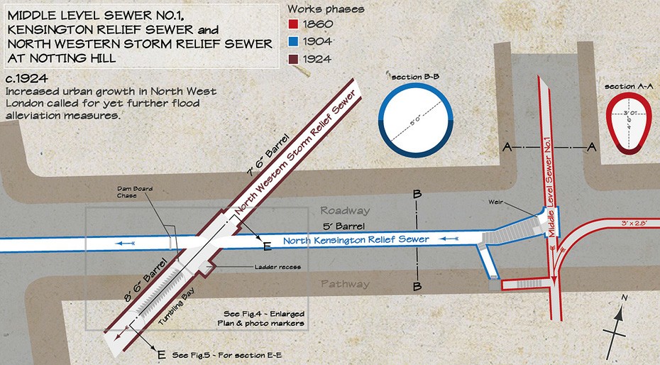
Fig. 3 – Phase Three: The NWSRS dissects the Kensington Relief Sewer.
Immediately downstream of this crossroads the NWSRS drops down a tumbling bay of twenty steps as it continues its journey south to its submerged outfall at the Thames. Fig.4 & 5 below show the locations of the photographs and hopefully help to clarify the relation between phases of work.

Fig. 4 – Photo markers and crossing point detail.

Fig. 5 – Photo markers and section E – E.
Below are the remaining images associated with the markers on Fig.4 & 5 which further illustrate the relationship between the various phases of work.

Pic. 4 – Oak dam boards and arcs.

Pic. 5 – Looking north at the crossing.
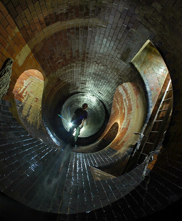
Pic. 6 – A parting shot. Please excuse the angle, I need a wider lens.


Your updates may take a while but are certainly worth waiting for. Interesting explanation, well put together diagrams and great photos!
really good pictures of the brickwork and of the tunnels themselves. the historical context is of great informational value. thanks for sharing this material.
Jd. I gotta say. Your anorak, is of the finest, fiiiinest qualitaaaaay! 😀
Told you i’d have a look! great pictures mate
congrats! serious and thorough work!
An enjoyable and informative read, thanks!
@ s-hi-o-lo-jen:
Ah yes, Parka wearing drain splorin. 🙂
@ Dan Chant:
LOL! Cheers Dan. Don’t go jumping down any manhole covers in Jinja! Scary thought.
@ Everyone else:
Thanks for the comments, much appreciated.
Thanks for such a clear explanation of how Labyrinth is connected to the other drains and how the system evolved. The pictures make a lot more sense to me now after seeing the diagrams!
Great stuff as ever.
JD, I sent you a contact message about possible collab, did you get it? (emails to your previous addy are bouncing). No worries if the answer’s negative. Cheers, Ant
This now makes sense to me! Excellent post, very thorough!
Your whole site never ceases to make me spooge Jondoe. This is no exception.
love love love
Awesome photographs – who knew that the drainage system looked like that 🙂 The photos are so good they almost make me want to go underground … almost.
Hi, i’ve been interested in urban exploration (the armchair version at nearly 51 years of age) and I have to say your reports and the level detail and information is absolutely amazing, the pictures and photography overall are beautiful; thank you so much. I’d love to register for your site but haven’t worked out how to yet because i only discovered it today from a link on guerillaexplorer and have been too overawed by the reports to work it out! J